


Plate Tectonics – Earthquakes, Volcanoes & Mountains BUNDLE
$14.78
Volcanoes, Earthquakes and Mountains. Why do they occur? How does plate tectonics explain the cause of volcanoes, earthquakes and other large-scale geologic interactions and land formations.

Volcanoes, Earthquakes and Mountains. Why do they occur? How does plate tectonics explain the cause of volcanoes, earthquakes and other large-scale geologic interactions and land formations.
Plate Tectonics Stations Include
- Vocabulary Cards in two formats with and without pictures.
- Watch – Students watch one of two videos and then answer questions about the videos. Videos include: volcanoes and the structure of the Earth.
- Play – Students play a video game and learn about different types of maps or about volcanoes. Students answer questions to reinforce the new learning.
- Investigate – Students read about earthquakes. They construct a building in order to investigate what happens to buildings during earthquakes. Students then answer questions to reinforce the concepts learned.
- Diagram – Students read about feature of the ocean floor and how scientists make seafloor maps. They make a models and diagrams of the seafloor. They then make a map (diagram) of a seafloor and answer questions in order to reinforce what they have learned.
- Read a Passage – Students read about the Pacific Ring of Fire. They answer questions in order to reinforce what they have learned.
- Model – Students read about plate tectonics and plate boundaries. They build models of plate boundaries. They answer questions in order to reinforce what they have learned.
- Explore Students read about and explore volcanoes using a simulation. They then answer questions about the exploration.
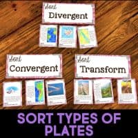
- Sort – Students read about the geologic features created at the three types of plate boundaries. They sort these features into plate boundary categories. Students then answer questions in order to reinforce what they have learned.
Google Classroom™️ Components Include:
- Google Form™️ with Reading Passage & Differentiated Questions (for Watch, Investigate, Diagram, Read, Model, Explore and Sort)
- Google Slides™️ with Activity Directions & Worksheets (for Investigate, Diagram, Model, Explore, Sort)
Each station is designed to last about 15-20 minutes. Students may do one a day for eight days, two a day for four days, or any format that works for your classroom. Because there are additional activities for the Watch and Play stations, you can offer those as a choice within that station or offer them as an early finisher station, as well.
These Fourth Grade Next Generation Science Standards include 8 different science stations where students deepen their understanding of plate tectonics. The focus is on 4-ESS2.B. Concepts include volcanoes, the structure of the Earth, types of maps, features of the ocean floor, seafloor maps, the Pacific Ring of Fire, plate boundaries, and geographic features caused by plate boundaries.
By working through this set of stations, students will gain a robust understanding of plate tectonics. Every station in this set meets the Crosscutting Concept: Patterns “Patterns can be used as evidence to support an explanation.” Each station addresses how scientists can understand how large-scale interactions (volcanoes and other landforms, earthquakes, etc.) explain and are explained by plate tectonics.
In Fourth Grade, students are expected to “Analyze and interpret data from maps to describe patterns of Earth’s features” (4- ESS2-1). This correlates with the DCI 4-ESS2.B, which states, “The locations of mountain ranges, deep ocean trenches, ocean floor structures, earthquakes, and volcanoes occur in patterns. Most earthquakes and volcanoes occur in bands that are often along the boundaries between continents and oceans. Major mountain chains form inside continents or near their edges. Maps can help locate the different land and water features areas of Earth.” All stations in this set meet the DCI, helping students gain an understanding of plate tectonics and how it explains volcanoes, earthquakes, and other large-scale geologic interactions and land formation. The Engineering Practice of “Analyze and interpret data to make sense of phenomena using logical reasoning” is part of the Investigate, Diagram, Model, and Explore stations.

Traci Crass –
This was a great resource for teaching plate tectonics, volcanoes, and earthquakes in my 4th grade science class. The worksheets and activities helped my students better understand how Earth’s surface changes and why earthquakes and volcanoes occur in certain locations. The materials were clear, easy to use, and worked well for reinforcing key concepts during our Earth science unit. My students were very engaged, and it helped support the standards we cover in 4th grade science. I would definitely recommend this resource to other teachers!
courtney L. –
Used this with my high school self-contained students. Found this resource to be very helpful and engaging. Thank you.
Jeanette D. –
Used this in a SpEd Global Science class and I loved the resource. It is nicely laid out and was a great addition to our material.
Carma A. –
Love the passages and engaging activities. Students very engaged in this topic.
Samantha H. –
Great resource for online learning. Took a lot of prep work off of my plate.