


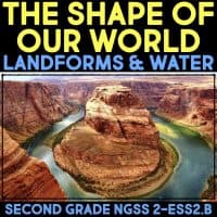
The Shape of Our World – Second Grade Science Stations
$12.78
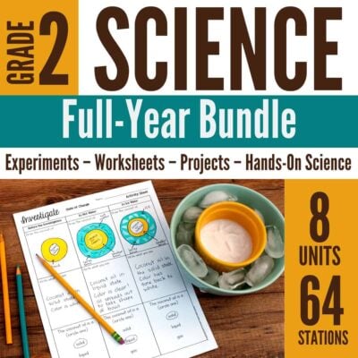
In this set of science stations, students learn how maps show where things are located and how to map the shapes and types of land and water in any area. It includes 8 different science stations where students deepen their understanding of maps, the globe, reading maps, plates, bodies of water, and landforms. All stations in this set meet the DCI 2-ESS2.B and incorporate ETS1.C.
In this set of science stations, students learn about how maps show where things are located and how one can map the shapes and kinds of land and water in any area. It includes 8 different science stations where students deepen their understanding of maps, the globe, reading maps, plates, bodies of water, and landforms. All stations in this set meet the DCI 2-ESS2.B and incorporate ETS1.C. See below for details on how these stations meet the standards and specific DCIs.
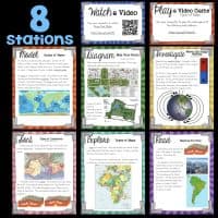
The Shape of Our World Stations Include
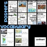
► Big Idea Posters that explain the core ideas of the stations.
► Vocabulary Cards in two formats with and without pictures.
► Watch – Students watch a video in order to learn about globes or about landforms and bodies of water. They answer questions in order to reinforce what they have learned.
► Play – Students play a game in order to learn about types of maps or learn how to read a map. They answer questions in order to reinforce what they have learned.
► Investigate – Students read about the compass rose on maps and how to use a compass. They make a compass in order to investigate this. They answer questions in order to reinforce what they have learned.
► Diagram – Students read about maps and scale. They make a map of the classroom, drawn to scale, and answer questions in order to reinforce what they have learned.
► Read a Passage – Students read about how maps show details of plate tectonics. They answer questions in order to reinforce what they have learned.
► Model – Students read about bodies of water and put together a map in order to create a model of where bodies of water are with respect to landforms. They answer questions in order to reinforce what they have learned.
► Explore Students read about and explore types of maps. They answer questions in order to reinforce what they have learned.
► Sort – Students read about types of landforms and how they are made. They sort them into categories of whether they are being built up or eroding. They then answer questions in order to reinforce what they have learned.
MP3 AUDIO
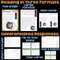
Now includes all MP3 audio of all text passages. You can access the MP3 via a website or install them on your devices to have students listen to the texts read aloud to them.
DIFFERENTIATED RESPONSES
Each station includes four different ways to respond to the experience at the station: short answer questions, fill-in the blank questions, task cards with short answers, task cards with multiple choice. All the variations are similar to one another. Choose the format that best fits your classroom and students. Students are encouraged to use their science journal, but worksheets are included as well.
Each station is designed to last about 15-20 minutes. Students may do one a day for 8 days, 2 a day for four days, or any format that works for your classroom. Because there are additional activities for the Watch and Play stations, you can offer those as a choice within that station or offer them as an early finisher station, as well.
NGSS Standards
In Second Grade, students are expected to demonstrate understanding in the following area:
• 2-ESS2-2. Develop a model to represent the shapes and kinds of land and bodies of water in an area.
This correlates with the DCI 2-ESS2.B, which states:
• Maps show where things are located. One can map the shapes and kinds of land and water in any area.
The Investigate, Model, and Explore stations correlate with the Engineering Design DCI ETS1.C, which states:
• Because there is always more than one possible solution to a problem, it is useful to compare and test designs. (K-2-ETS1-3)
The Investigate, Diagram, Model, and Explore stations meet the Science and Engineering Practices:
• Developing and Using Models: Modeling in K–2 builds on prior experiences and progresses to include using and developing models (i.e., diagram, drawing, physical replica, diorama, dramatization, or storyboard) that represent concrete events or design solutions. Develop a model to represent patterns in the natural world. (2-ESS2-2) The Investigate, Diagram, Explore, and Model Stations use models to compare different types of maps or mapping tools.
• Constructing Explanations and Designing Solutions: Constructing explanations and designing solutions in K–2 builds on prior experiences and progresses to the use of evidence and ideas in constructing evidence-based accounts of natural phenomena and designing solutions. Compare multiple solutions to a problem. (2-ESS2-1) The Investigate, Diagram, Explore, and Model Stations allow students to compare maps or mapping tools. They can optionally compare these between groups.
• Obtaining, Evaluating, and Communicating Information: Obtaining, evaluating, and communicating information in K–2 builds on prior experiences and uses observations and texts to communicate new information. Obtain information using various texts, text features (e.g., headings, tables of contents, glossaries, electronic menus, icons), and other media that will be useful in answering a scientific question. (2-ESS2-3)Every Station in this set provides students with information about maps. Moreover, the Diagram, Explore, and Model Stations allow students to gain information about maps by making maps and mapping tools.

Megan Cyrus –
This resource made it so much easier to teach the science standards without having a curriculum to follow. The different lessons built on each other and students were able to grasp the concepts being taught.
Sandra R. –
My second graders loved using this resource. It was very useful resource and easy to use.
Leah F. –
The readers are great for building background knowledge, and they are decodable for young readers.
The Long Neck Coloring Shop –
I've used this with ELLs.
Mindy C. –
Your resources are always GREAT!! Thank YOU!!